Biodiversity Net Gain
One of the aims of the Government’s 25-year Environment Plan, is to “leave the environment in a better state than we found it”. One way the Government hope to achieve this is found in the Environment Act which, as of February 2024, requires developers to produce a 10% net gain on the biodiversity lost as a result of development. This net gain comes from creating or enhancing habitats, this can be done on the development site, or off site.
Developers must set out how their net gain will be achieved as part of their planning obligation. Whilst they are encouraged to provide net gain on site, if possible, many will have to either purchase land to create/improve habitat or pay someone to establish it for them. For farmers and landowners this represents an opportunity to create income from unprofitable areas of land (as well as productive areas) and can complement the holding’s areas of productive farming. There is also the potential for synergy with other areas of ‘natural capital’ e.g. carbon sequestration or nutrient neutrality. However, it is important to note that the land will be locked out of intensive agricultural production for 30 years. This will be legally using a section 106 or a conservation covenant which outline how the relevant LPA will monitor and enforce your habitat creation/enhancement. The habitat creation/enhancement is quantified by ‘biodiversity units’ calculated using the Statutory Biodiversity Metric.
TCS Habitat Distinctiveness/”Rarity” Pyramid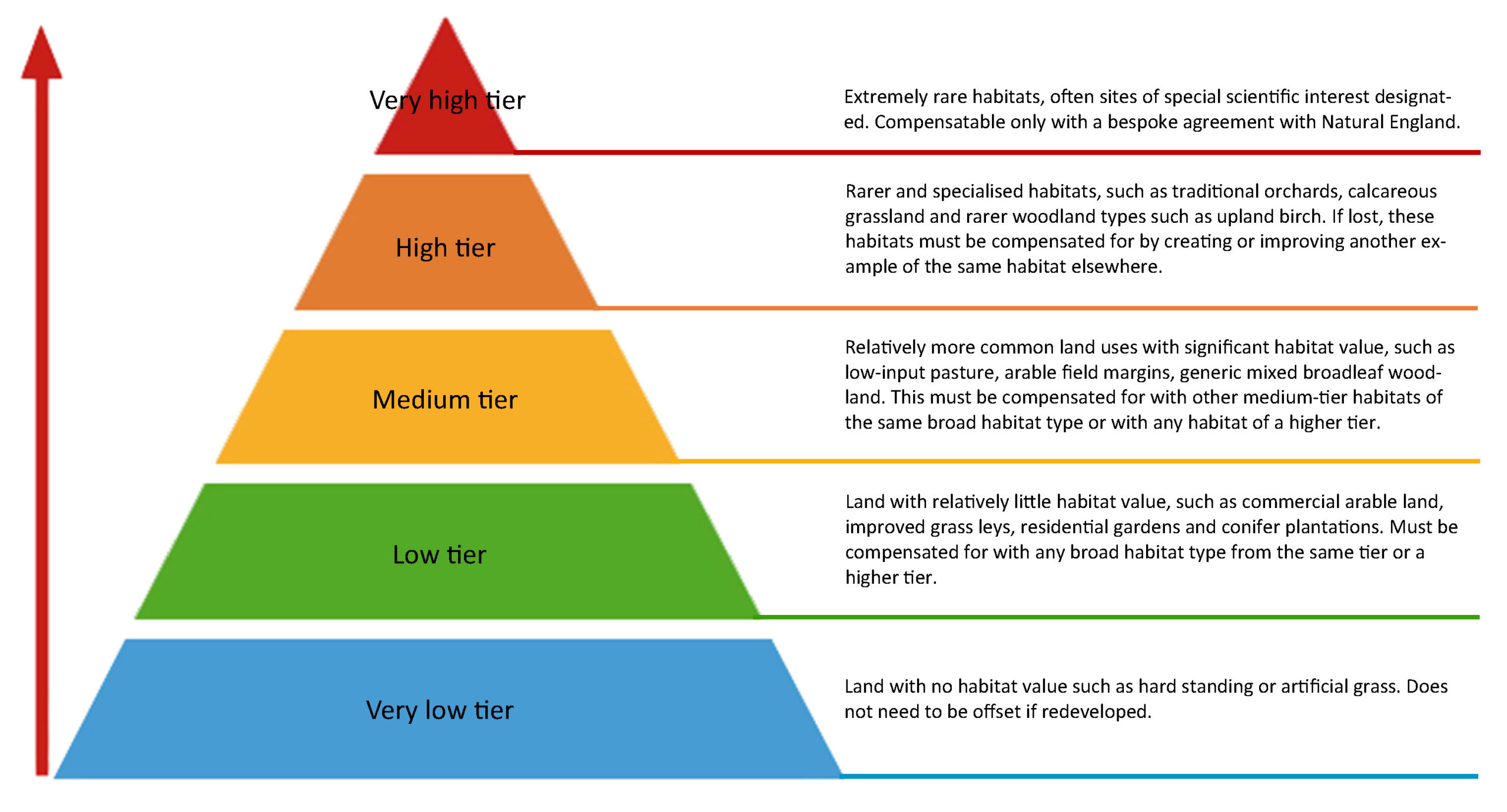 TCS Habitat Distinctiveness/”Rarity” Trading Pyramid TCS Habitat Distinctiveness/”Rarity” Trading Pyramid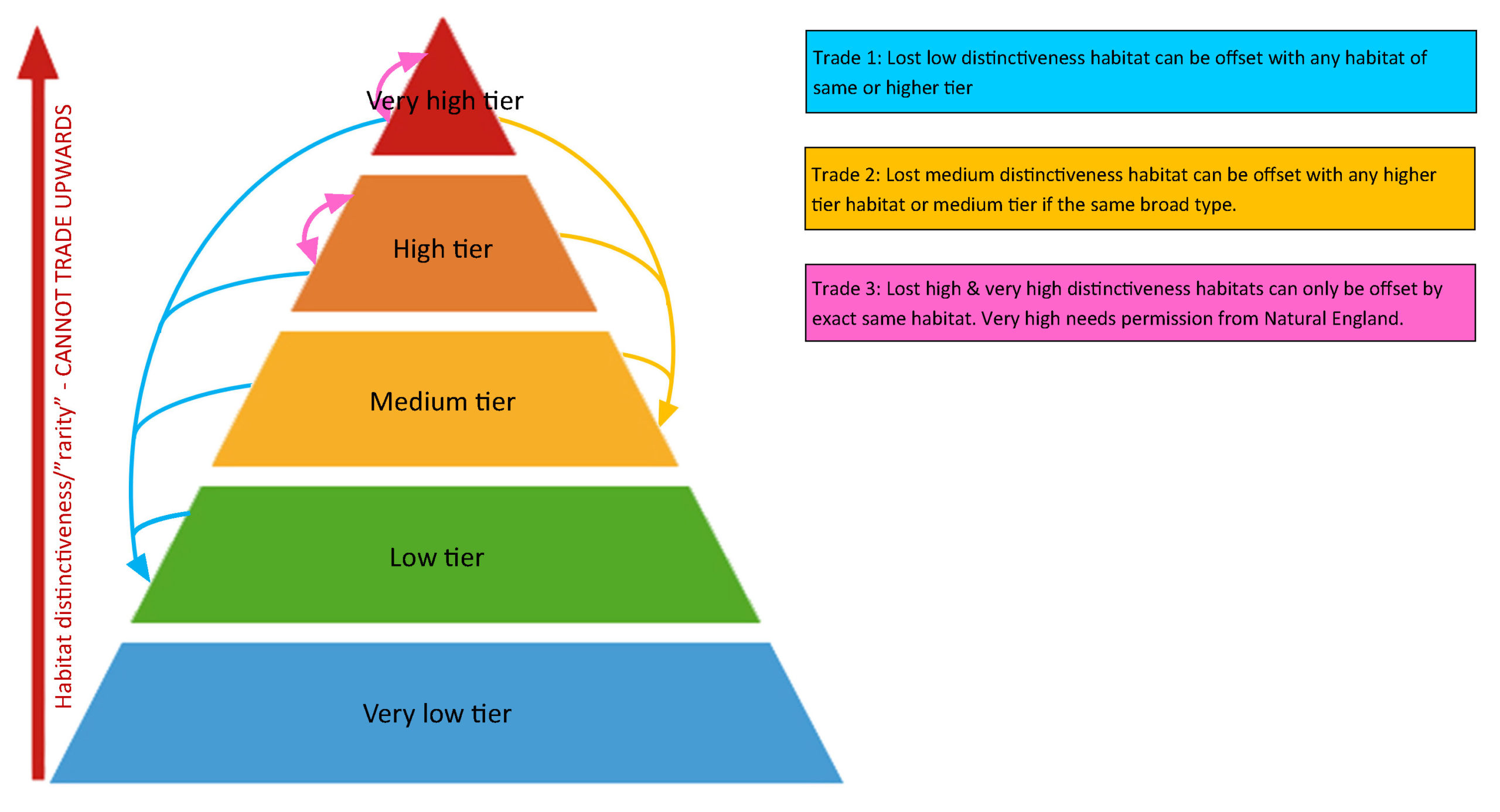 Infographic showing how different distinctiveness habitats can be used for offsetting. Very Low Distinctiveness habitats cannot be used for offsetting and currently do not require it if lost. Low Distinctiveness habitats can only offset other low distinctiveness habitats, and can be offset by any habitat of the same distinctiveness or higher. Medium Distinctiveness habitats can offset any low distinctiveness habits, or medium distinctiveness habitats of the same broad type (arable, woodland, grassland etc), and can be offset by medium distinctiveness habitats of the same broad type or any habitat of higher distinctiveness. High Distinctiveness habitats must be offset by the exact same habitat in a different location (e.g. upland birchwood can only be offset by more upland birchwood), and can offset losses of the same habitat elsewhere or any medium distinctiveness or low distinctiveness habitat. Very High distinctiveness habitats behave in the same way as high distinctiveness habitats, except that offsetting them requires special permission from the Secretary of State. This system therefore suggests the best prices for any unit from any LPA area will most likely only be achieved if marketed nationally. For a full explanation of the TCS pyramid click here. |
Example of calculating a site’s biodiversity units
Calculating original site’s baseline
There are several factors and multipliers involved in calculating the units a site will lose or gain including area, distinctiveness, condition, strategic significance, impact of development, time to reach desired level, difficulty of establishment, risk and proximity to development site. The higher the development site’s biodiversity, the more habitat will be lost from the development and in turn required from off-site projects to make up a 10% net gain. This process will discourage new development on sites of high biodiversity.
First the baseline of the area to be developed is established. Then the impact of the developmental actions and any existing habitat lost (and any on-site gains that are created) are calculated and adjusted from the baseline. After the developer has established the on-site losses, they must try to deliver on-site gains. Where this does not reach 10% net gain, they must look for off-site schemes.
Unit Calculations for Offsite creation/enhancement
- Establish Offsite Baseline
The area in ha or length in km for rivers/hedgerows is worked out. There is no specific minimum or maximum size but under a certain threshold would be uneconomical. Local authorities are in the process of creating Local Nature Recovery Strategies and if the location of a site is within such an area it receives a 15% boost to the number of units generated. If it is considered to be in a desirable location but not within an official strategic site it may receive a 10% boost subject to the Local Authority’s agreement.
Every habitat is given a distinctiveness score between 0 and 8 based on its rarity, proportion in SSSIs and its UK Priority status. This is multiplied by the area.
This is combined with the condition of the existing habitat (or proposed habitat) ranging from x1 (Poor) to x3 (good). Certain habitats like cereal crops are automatically classed as as N/A (no multiplier).
This creates the starting point for the number of units available.
As an example, 2 ha of arable would represent:
2 (Area) x 2 (‘Low’ Distinctiveness) x 1 (Condition) x 1 (‘Low’ Strategic Significance) = 4 Units
- Account for Loss of existing habitat
The impact of enhancing a site (as it will have some habitat value already) must be calculated and subtracted from the post-intervention figure. This is the area before enhancement or having new habitat created upon it.
- Account for Gain of created/enhanced habitat
The created/enhanced habitat value must be calculated, as when establishing the baseline, but using the new type of habitat or new condition scores with the following multipliers:
Spatial risk – The distance of the new site to the developer’s site will negatively impact the amount of usable units by 25% if in a neighbouring Local Authority area and 50% if further afield.
Difficulty of creation and time – The time it takes for enhancement or creation of a habitat to reach its desired potential will impact units with up to a 70% reduction if it takes 30 years or longer. The higher the difficulty will reduce the value by up to 10%.
Example – If the above arable site was used to create Gorse Scrub:
2 (Area) x 4 (‘Medium’ Distinctiveness) x 3 (‘Good’ Condition) = 24
x 1 (‘Low’ Strategic Significance) = 24
x 0.7 (Remoteness: 10+ years to establishment) x 1 (‘Low’ Difficulty of creation)
x 1 (Spatial Risk: Within same LPA)
= 16.81 Units minus 4 (Baseline Units Lost)
Net Units = 12.81
The type of habitat, whether created or enhanced must be carefully considered as factors such as time taken to establish will drastically affect the number of units produced. The land manager must also consider how BNG complements the rest of the business and the opportunity costs of taking land out of intensive production. Whilst it may seem simpler to sell land to developers and let them create habitat for themselves, retaining the land allows one to sell BNG units and continue farming to an extent (depending on the type of habitat created/enhanced) thus allowing the landowner to make the most of their ‘natural capital’.
Developers/Purchasers of credits
- Before development works begins, but after planning permission is given a biodiversity gain plan must be approved by a planning authority.
- This plan will show how the net gain target will be achieved and how the biodiversity value has been calculated. This will remove the planning obligation to show gain. If the development has been permitted under a development order, such as permitted development rights then it does not need a biodiversity gain plan.
- The ‘net gain’ will be calculated by calculating the pre-development biodiversity value (at the time of planning application submission) and deducting it from the post-development biodiversity value (which will include onsite habitat improvements where possible).
- The post-development value may include biodiversity only realised years in the future if it is a long-term project.
- Biodiversity value may include off-site options such as purchasing ‘habitat units’ from a site registered on the Natural England’s ‘biodiversity gain register’.
Contact us for help acquiring suitable land that matches your offsetting needs.
Landowners/Vendors
If you would like to commission a Biodiversity report (HMMP) to establish your land’s baseline value and suitable habitat interventions to create net units then contact us for our welcome pack which explains what you need to provide to enable us to quote for carrying out a site survey and assessment.
If you have land ready for the ‘biodiversity gain register’ having completed your HMMP then contact us to discuss your options and help you with the unit sale stage. You would need to provide your completed HMMP and Statutory Metric.
Biodiversity value
DEFRA originally proposed an outline tariff of £9,000 to £12,000 per biodiversity unit however more recent consultations suggested £20,000 to £25,000/unit. It is hoped to make it attractive to sellers by determining not to use compensatory or income foregone models of remuneration. However, it will depend on a case by case basis. An example of a high paying habitat would be converting arable fields to other neutral grassland producing 4.69 units/ha, subject to the land being capable of this conversion. This could potentially make up a payment of £93,800 at £20,000/unit or £1,265/acre per annum for 30 year (not factoring in when the sales are achieved which may be in year 1 up to year 30). Putting one hectare of modified grassland into lowland meadow may yield a net 8.64 units in certain conditions (distance, within a formally identified area etc.) This would result in £172,800 at the point of sale or £2,331/acre per annum for 30 years if they were to sell in year 1 and assuming units fetch these suggested values. Note that receiving any money is dependant on completing sales, a process that may take some time, selling all units is dependant on supply and demand and you may not sell any one specific unit for many years.
What we can do for you:
- Please register your interest with us now to take advantage of Biodiversity Net Gain.
- We can advise on suitability of areas for Biodiversity Net Gain.
- Our surveying team will calculate the potential Biodiversity Units using the DEFRA Statutory Biodiversity Metric, created by the actions you will undertake on your land.
- For those looking to acquire Biodiversity units we can add you to our register and match you to a site that suits your requirements and location.
- For our user guide on Biodiversity net gain email us for our welcome pack
- We also value land for investment purposes with consideration for an array of environmental credits and ‘natural capital’ whether that be woodland creation for carbon units or habitat improvement for BNG.
Further information
Fact Sheet 15 – How is Biodiversity Net Gain marketed? here
List of Broad Habitat Type, Habitat Type and Distinctiveness/”Rarity” Tier here
Indicative Price List of Statutory Credits available from Natural England 27-7-23 here

Alasdair Squires
BA(Hons).
01392 823935
enquiries@townsendcharteredsurveyors.co.uk