
TCS Brokerage – Wanted/Available
Townsend Chartered Surveyors has been trading in intangible farm/land assets for over 30 years since 1992, having over 37 years of experience in this market, and is the UK’s leading broker. With a wealth of knowledge TCS Brokerage can ensure you achieve the best from your sale or purchase.
| BNG – NATIONAL SALES BY PRIVATE TREATY |
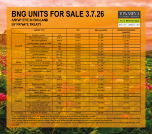
Set out above are some of TCS units available from all over England and available for sale by private treaty. They are compared with the lowest prices advertised on Gaia and reported by Biodiversity Units UK. Further TCS discounts can also be available depending on lot size and the ‘bundle’ of the different habitats needed.
To illustrate the current ‘two-tier’ market go to Gaia BNG Marketplace and change the filter button in the top right from ‘Relevance’ to ‘Price: low to high’. This will bring the cheapest prices nationally to the top of your screen, you will see that at the moment, the top 12 are TCS sites. The average price differential for area and hedgerow habitats as listed above between the advertised prices of TCS and the next lowest on Gaia is £7,300 and on Biodiversity Units UK is £16,000 cheaper per unit. For some habitats TCS is £37,800 cheaper.
To enquire as to the availability of any of the above units please email bng@townsendcharteredsurveyors.co.uk or view our listings on Gaia BNG Marketplace. To ensure purchasers obtain the most reasonable prices on Gaia, from the national market, search first by habitat type and not region, LPA or NCA. Let us know what you are after and we will confirm whether this is one of our vendors who will bear the SRM, meaning the asking price will remain the overall cost of the developer receiving these units “delivered to the development site.
As stated above, asking prices are per unit, subject to contract, LPA/RB approval, VAT, lot sizes and the ‘bundle’ of different habitats needed, with potential further discounts available including where vendor bears SRM.
| BNG – TENDER – 17th August 2026 – LOT REGISTER click here |
| BNG AVAILABLE – England – Units currently being sold. For number of units available please contact us. |
||||
| REF. | LPA/NCA/LNRS | ADJOINING LPAs/NCAs/LNRSs | HABITAT TYPE | NUTRIENT NEUTRALITY Catchment / No. of units |
| A1 | Dartmoor National Park Authority / The Culm/ Devon | Teignbridge, South Hams, West Devon, Mid Devon / Cornish Killas, South Devon, Dartmoor, Devon Redlands, Exmoor / Cornwall and the Isles of Scilly, Dorset, Somerset | Lowland meadow | |
| Other neutral grassland | ||||
| Hedgerows | ||||
| A2 | South Somerset DC / Somerset Levels & Moors / Somerset | Dorset, East Devon, Mendip, Sedgemoor, Somerset West & Taunton, Wiltshire / Mid Somerset Hills, Yeovil Scarplands, Mendip Hills, Vale of Taunton & Quantock Fringes, Bristol, Avon Valleys & Ridges / West of England, Devon, Dorset, Wiltshire and Swindon | Lowland meadow | |
| Other neutral grassland | ||||
| Ponds | ||||
| Hedgerows | ||||
| A3 | East Suffolk Council / South Norfolk & High Suffolk Claylands /Suffolk | Suffolk Coast & Heaths, South Suffolk & North Essex Clayland, The Brecks, Mid Norfolk / Norfolk, Greater Essex, Cambridgeshire and Peterborough | Lowland meadow | |
| A4 | Shropshire Council / Mid Severn Sandstone Plateau / Shropshire and Telford & Wrekin | Herefordshire, Malvern Hills, Wyre Forest, Dudley, South Staffordshire, Telford & Wrekin, Stafford, Newcastle-under-Lyme, Cheshire East, Cheshire West & Chester / Shropshire Hills, Shropshire, Cheshire & Staffordshire Plain, Cannock Chase & Cank Wood, Arden, Severn & Avon Vales, Teme Valley / Cheshire, Staffordshire and Stoke-on-Trent, Worcestershire, Herefordshire | Other neutral grassland | |
| Lowland mixed deciduous woodland | ||||
| Ponds | ||||
| A5 | Herefordshire Council / Herefordshire Lowlands / Herefordshire | Shropshire, Malvern Hills, Forest of Dean / Clun & North West Herefordshire Hills, Shropshire Hills, Teme Valley, Herefordshire Plateau, South Herefordshire & Over Severn, Black Mountains & Golden Valley / Shropshire and Telford & Wrekin, Worcestershire, Gloucestershire | Mixed scrub | |
| Other neutral grassland | ||||
| Other woodland; broadleaved | ||||
| Pond (non-priority habitat) | ||||
| A6 | Torridge DC / The Culm / Devon | Cornwall, Mid Devon, North Devon / Cornish Killas, Dartmoor, Devon Redlands, Exmoor, South Devon / Cornwall and the Isles of Scilly, Dorset, Somerset | Other neutral grassland | |
| A7 | Malvern Hills / Severn & Avon Vales / Worcestershire |
Worcester, Herefordshire / Malvern Hills, Teme Valley, Herefordshire Plateau / Gloucestershire, West Midlands, Warwickshire, Stafforshire and Stoke-on-Trent, Shropshire and Telford & Wrekin, and Herefordshire |
Medium & high distinctiveness grassland | |
| Water courses – ditch | ||||
| A8 | Buckinghamshire Council / Upper Thames Clay Vales / Buckinghamshire and Milton Keynes |
Windsor & Maidenhead, Wokingham, South Oxfordshire, Cherwell, West Northamptonshire, Milton Keynes, Central Bedfordshire, Three Rivers, Hillingdon, Slough / Chilterns, Berkshire & Marlborough Downs, Avon Vales, Midvale Ridge, Cotswolds, Bedfordshire & Cambridgeshire Claylands / Bedfordshire, Hertfordshire, Greater London, Berkshire, Oxfordshire, West Northamptonshire, North Northamptonshire |
Other neutral grassland | |
|
Hedgerows |
||||
| A9 | Dorset Council / Yeovil Scarplands / Dorset |
Bournemouth Christchurch & Poole, East Devon, New Forest, South Somerset, Wiltshire / Blackdowns, Blackmore Vale & Vale of Wardour, Dorset Downs & Cranborne Chase, Marshwood & Powerstock Vales, Mendip Hills, Mid Somerset Hills, Somerset levels & moors / Devon, Somerset, Wiltshire and Swindon, Hampshire |
Lowland meadow | |
| Ponds | ||||
| Rural tree | ||||
| Hedgerow | ||||
| A10 | Somerset Council – South Team / Yeovil Scarplands / Somerset | Dorset, East Devon, Mendip, Sedgemoor, Somerset West & Taunton, Wiltshire / Blackdowns, Blackmore Vale & Vale of Wardour, Dorset Downs & Cranborne Chase, Marshwood & Powerstock Vales, Mendip Hills, Mid Somerset Hills, Somerset levels & moors / West of England, Devon, Dorset, Wiltshire and Swindon | Lowland meadow | |
| A11 | Somerset Council – West Team / Vale of Taunton & Quantock Fringes / Somerset | East Devon, Exmoor National Park, Mid Devon, Sedgemoor, South Somerset / Blackdowns, Exmoor, Somerset Levels & Moors, Yeovil Scarplands / West of England, Devon, Dorset, Wiltshire and Swindon | Lowland meadow | Phosphate Tone – Upper 11.92 |
| A12 | Northumberland CC / Mid Northumberland / Northumberland |
Allerdale, Carlisle, Co Durham, Eden, Gateshead, Lake District National Park, Newcastle upon Tyne, North Tyneside, Northumberland National Park, Sunderland / Northumberland Sandstone Hills, South East Northumberland Coastal Plain, Tyne & Wear Lowlands, Tyne Gap & Hadrians Wall / South of Tyne and Wear, County Durham, Cumbria |
Wet heathland (Upland) | |
| Dry heathland (Upland) | ||||
| Acid grassland | ||||
| Mixed native scrub | ||||
| Continuous bracken | ||||
| A13 | Mid Suffolk DC / South Norfolk & High Suffolk Claylands / Suffolk |
Babergh, Breckland, Broadland, East Suffolk, Great Yarmouth, Ipswich, South Norfolk, West Suffolk / Mid Norfolk, South Suffolk and North Essex Clayland, Suffolk Coast and Heaths, The Brecks, The Broads / Norfolk, Greater Essex, Cambridgeshire and Peterborough |
Lowland meadow | |
| Neutral grassland | ||||
| A14 | Cornwall Council / Cornish Killas / Cornwall and the Isles of Scilly |
Plymouth, Torridge, West Devon / Bodmin Moor, Carnmenellis, Hensbarrow, The Culm, West Penwith, The Lizard / Devon |
Lowland meadow | |
| Pond (priority habitat) | ||||
| Hedgerows | ||||
| A15 | Torridge DC / The Culm / Devon |
Cornwall, Mid Devon, North Devon / Cornish Killas, Dartmoor, Devon Redlands, Exmoor, South Devon / Cornwall and the Isles of Scilly, Dorset, Somerset |
Other neutral grassland | |
| Native hedgerow – associated with bank or ditch | ||||
| A16 | Teignbridge DC / The Culm / Devon | Dartmoor National Park; South Hams; West Devon; Mid Devon / Cornish Killas; South Devon; Dartmoor; Devon Redlands; Exmoor / Cornwall and the Isles of Scilly, Dorset, Somerset/ Cornwall and the Isles of Scilly, Dorset, Somerset | Lowland meadow | |
| A17 | East Suffolk Council/Suffolk Coast & Heaths / Suffolk |
Great Yarmouth, Ipswich, Mid Suffolk, The Broads Authority / The Broads, South Norfolk & High Suffolk Claylands, South Suffolk & North Essex Clayland, Northern Thames Basin/ Norfolk, Greater Essex, Cambridgeshire and Peterborough |
Lowland dry acid grassland | |
| Other neutral grassland | ||||
| Lowland heathland | ||||
| Mixed scrub | ||||
| Ponds (non-priority habitat) | ||||
| Broadleaved woodland | ||||
| A18 | Wiltshire Council/Blackmoor Vale & Vale of Wardour / Wiltshire | Bath & North East Somerset, Cotswold, Dorset, Mendip, New Forest, New Forest National Park, South Gloucestershire, South Somerset, Swindon, Test Valley, West Berkshire / Avon Vales, Dorset Downs & Cranborne Chase, Mendip Hills, Salisbury Plain & West Wiltshire Downs, Yeovil Scarplands / Hampshire, Dorset, Somerset, West of England, Gloucesterhsire, Oxfordshire, Berkshire | Lowland meadow | |
| A19 | Exmoor National Park/Exmoor/Devon |
Mid Devon, North Devon, Somerset West & Taunton / Devon Redlands, The Culm, Vale of Taunton & Quantock Fringes/ Cornwall and the Isles of Scilly, Dorset, Somerset |
Lowland meadow | |
| Lowland mixed deciduous woodland | ||||
| Other woodland; mixed | ||||
| Native hedgerow with trees | ||||
| A20 | Mid Devon District Council/Exmoor/Devon |
Dartmoor National Park, East Devon, Exmoor National Park, North Devon, Somerset West & Taunton, Teignbridge, Torridge / Devon Redlands, The Culm, Vale of Taunton & Quantock Fringes / Cornwall and the Isles of Scilly, Dorset, Somerset |
Lowland meadow | |
| Native hedgerow with trees | ||||
| A21 | Somerset /Mid Somerset Hills / Somerset |
Dorset, East Devon, Mendip, Sedgemoor, Somerset West & Taunton, Wiltshire / Yeovil Scarplands, Blackdowns, Vale of Taunton and Quantock Fringes, Somerset Levels and Moors / West of England, Devon, Dorset, Wiltshire and Swindon |
Lowland meadow | Phosphate Parrett 20, Brue 20 |
| Mixed scrub | ||||
| Wet woodland | ||||
| Other woodland; mixed | ||||
| Rural trees | ||||
| A22 | Cornwall Council/The Cornish Killas/Cornwall and the Isles of Scilly |
Plymouth, Torridge, West Devon / Bodmin Moor, Carnmenellis, Hensbarrow, The Culm, West Penwith, The Lizard / Devon |
Maritime cliff & slopes | |
| Lowland heathland | ||||
| Other neutral grassland | ||||
| A23 | Cheshire East Council/Shropshire, Cheshire & Staffordshire Plain/Cheshire | Cheshire West and Chester, Warrington, Trafford, Manchester, Peak District National Park, Staffordshire Moorlands, Newcastle-under-Lyme, Shropshire, Stockport / Cheshire Sandstone Ridge, Mersey Valley, Manchester Conurbation, South West Peak, Potteries and Churnet Valley / Liverpool City Region, Greater Manchester, Derbyshire, Staffordshire and Stoke-on-Trent, Shropshire and Telford & Wrekin | Other neutral grassland | |
| A24 | Isle of Wight Council/Isle of Wight/Isle of Wight |
Chichester, Fareham, Gosport, New Forest, New Forest National Park, Portsmouth / New Forest, South Coast Plain / Hampshire |
Other neutral grassland | |
| Traditional orchards | ||||
| Other woodland; broadleaf | ||||
| Lowland meadow | ||||
| Water courses – ditches | ||||
| A25 | Sevenoaks District Council/High Weald/Kent and Medway |
Ashford, Bromley, Crawley, Croydon, Dartford, Folkstone & Hythe, Gravesham, Hastings, Mid Sussex, Mole Valley, Rother, Tandridge, Tonbridge & Malling, Tunbridge Wells, Wealden / Low Weald, Romney Marshes, Pevensey Levels / Greater Essex, Greater London, Surrey, East Sussex and Brighton & Hove |
Blackthorn scrub | |
| Lowland meadow | ||||
| Lowland mixed deciduous woodland | ||||
| Mixed scrub | ||||
| Other neutral grassland | ||||
| Other woodland; broadleaf | ||||
| Ponds (non-priority habitat) | ||||
| Rural tree | ||||
| A26 | Tandridge District Council/High Weald/Kent and Medway |
Ashford, Bromley, Crawley, Croydon, Folkestone & Hythe, Hastings, Mid Sussex, Mole Valley, Reigate & Banstead, Rother, Sevenoaks, Tunbridge Wells, Wealden / Low Weald, Romney Marshes, Pevensey Levels / Greater Essex, Greater London, Surrey, East Sussex and Brighton & Hove |
Lowland meadow | |
| Lowland mixed deciduous woodland | ||||
| Mixed scrub | ||||
| Other neutral grassland | ||||
| Other woodland; broadleaf | ||||
| Ponds (non-priority habitat) | ||||
| Rural tree | ||||
| A27 | Dorset Council / Blackmoor Vale & Vale of Wardour/Dorset |
Bournemouth Christchurch & Poole, East Devon, New Forest, South Somerset, Wiltshire / Yeovil Scarplands, Dorset Downs & Cranborne Chase, Salisbury Plain & West Wiltshire Downs, Avon Vales, Mendip Hills / Devon, Somerset, Wiltshire and Swindon, Hampshire |
Other neutral grassland | |
| Floodplain wetland mosaic & CFGM | ||||
| Reedbeds | ||||
| Traditional orchard | ||||
| Other woodland; broadleaf | ||||
| Rural trees | ||||
| Species-rich native hedgerow with trees | ||||
| A28 | South Hams District/Dartmoor/Devon |
Dartmoor National Park, Plymouth, Teignbridge, Torbay, West Devon / Devon Redlands, South Devon, The Culm / Cornwall and the Isles of Scilly, Dorset, Somerset |
Other neutral grassland | |
| Other lowland acid grassland | ||||
| Grassland – bracken | ||||
| Gorse scrub | ||||
| Mixed scrub | ||||
| Species-rich native hedgerow – associated with bank or ditch | ||||
| A29 | South Kesteven District Council / Trent & Belvoir Vales/Greater Lincolnshire |
Rutland, Melton, Newark & Sherwood, North Kesteven, South Holland, Peterborough, North Northamptonshire / Southern Lincolnshire Edge, Kesteven Uplands, Leicestershire & Nottinghamshire Wolds, Washlands, Sherwood, Humberhead Levels, Northern Lincolnshire Edge with Coversands / Hull and East Yorkshire, South Yorkshire, Nottinghamshire and Nottingham, Leicestershire, Liecester and Rutland, Cambirdgeshire and Peterborough, Norfolk |
Other neutral grassland | |
| Other woodland; broadleaved | ||||
| Species-rich native hedgerow – associated with bank or ditch | ||||
| A30 | West Northamptonshire Council – Daventry / Northamptonshire Uplands/West Northamptonshire |
Rugby, Harborough, North Northamptonshire, Milton Keynes, Buckinghamshire, Cherwell, Stratford-on Avon / Northamptonshire Vales, Yardley-Whittlewood Ridge, Cotswolds, Dunsmore & Feldon, Leicestershire Vales |
Other neutral grassland | |
| Species-rich native hedgerow | ||||
| Ponds | ||||
| A31 | Guildford / North Downs / Surrey |
Woking LPA, Elmbridge, Mole Valley, Waverley, Rushmoor, Surrey Heath / Thames Basin Lowlands, North Kent Plain, Wealden Greensand, Hampshire Downs, Thames Basin Lowlands / Greater London, Kent and Medway, West Sussex, Hampshire, Berkshire |
Other neutral grassland | |
| Traditional orchards | ||||
| Woodland | ||||
| Wetland | ||||
| Arable margin | ||||
| Mixed scrub | ||||
| A32 | South Downs National Park / South Downs / East Sussex and Brighton & Hove |
East Hampshire, Waverley, Chichester, Horsham, Mid Sussex, Lewes, Wealden, Eastbourne, Lewes, Brighton & Hove, Adur, Worthing, Arun, Chichester, Havant, East Hampshire, Winchester, Eastleigh / Hampshire Downs, Wealden Greensand, Low Weald, Pevensey Levels, South Coast Plain, South Hampshire Lowlands, Salisbury Plain & West Wiltshire Downs / Kent and Medway, Surrey, West Sussex |
other neutral grassland | |
| Hedgerows (heathland & scrub) | ||||
| Dew ponds | ||||
| Mixed scrub | ||||
| Broadleaved woodland | ||||
| A33 | Braintree / South Suffolk & North Essex Clayland / Greater Essex |
Babergh, Colchester, Maldon, Chelmsford, Uttlesford, South Cambridgeshire, West Suffolk / South Norfolk & High Suffolk Claylands, Suffolk Coast & Heaths, Northern Thames Basin, Chilterns, East Anglian Chalk, The Brecks / Norfolk, Greater Essex, Cambridgeshire and Peterborough |
Neutral grassland | |
| Broadleaved woodland | ||||
| A34 |
Hambleton / Tees Lowlands / Tees Valley |
Middlesbrough, Redcar & Cleveland, North York Moors National Park, Ryedale, York, Harrogate, Richmondshire, Darlington, Stockton-on-Tees / North York Moors & Cleveland Hills, Vale of Mowbray, Pennine Dales Fringe, Durham Coalfield Pennine Fringe, Durham Magnesian Limestone Plateau / County Durham, North Yorkshire and York |
Other neutral grassland | |
| Individual trees | ||||
| Mixed scrub | ||||
| Other woodland; broadleaved | ||||
| A35 | Redcar & Cleveland / Tees Lowlands / Tees Valley |
Middlesbrough, Hambleton, North York Moors National Park, Stockton-on-Tees, Hartlepool / North York Moors & Cleveland Hills, Vale of Mowbray, Pennine Dales Fringe, Durham Coalfield Pennine Fringe, Durham Magnesian Limestone Plateau / County Durham, North Yorkshire and York |
Other neutral grassland | |
| Mixed scrub | ||||
| Pond (non-priority) | ||||
| Other woodland; broadleaved | ||||
| A36 | County Durham / Durham Coalfield Pennine Fringe / County Durham |
Sunderland, Hartlepool, Stockton-on-Tees, Darlington, Richmondshire, Yorkshire Dales National Park, Eden, Northumberland, Gateshead / Tyne & Wear Lowlands, Durham Magnesia Limestone Plateau, Tees Lowlands, Pennine Dales Fringe, North Pennines, Tyne Gap & Hadrian’s Wall / South of Tyne and Wear, Northumberland, Cumbria, Tees Valley, North Yorkshire and York |
Other neutral grassland | |
| Mixed scrub | ||||
| A37 | Rugby Borough Council / Leicestershire Vales / Leicestershire, Leicester and Rutland |
Blaby, Harborough, West Northamptonshire, Stratford-on-Avon, Warwick, Coventry, Nuneaton & Bedworth, Hinckley & Bosworth / Dunsmore & Feldon, Arden, Mease/Sence Lowlands, Leicestershire & South Derbyshire Coalfield, High Leicestershire, Northamptonshire Vales, Northamptonshire Uplands / Nottinghamshire and Nottingham, Derbyshire, Staffordshire and Stoke-on-Trent, Warwickshire, West Northamptonshire, North Northamptonshire |
Other neutral grassland | |
| Native hedgerow with trees | ||||
| Rural trees | ||||
| A38 | Hertfordshire County Council / South Suffolk and North East Clayland National Character Area / Hertfordshire |
East Hertfordshire, North Hertfordshire, Stevenage, Welwyn Hatfield, Broxbourne, Epping Forest, Uttlesford / South Suffolk and North Essex Clayland, Northern Thames Basin, Chilterns, East Anglian Chalk, The Brecks, South Norfolk and High Suffolk Claylands, and Suffolk Coast and Heathlands / Bedfordshire, Cambridgeshire and Peterborough, Greater Essex, Greater London, Buckinghamshire | Other neutral grassland | |
| Mixed scrub | ||||
| Other woodland; broadleaved | ||||
| A39 | Wealden / Low Weald / Kent and Medway |
Lewes, Mid Sussex, Tandridge, Sevenoaks, Tunbridge Wells, Rother, Eastbourne, South Downs National Park / Pevensey Levels, South Downs, Wealden Greensand, Romney Marshes, High Weald / Greater Essex, Greater London, Surrey, East Sussex and Brighton & Hove |
Mixed scrub |
|
|
Other neutral grassland |
||||
| A40 | Breckland / South Norfolk and High Suffolk Claylands / Suffolk |
West Suffolk LPA, South Norfolk LPA, Mid Suffolk LPA, Broadland LPA, North Norfolk LPA, King’s Lynn and West Norfolk LPA / Mid Norfolk NCA, The brecks NCA, South Suffolk and North Essex Clayland NCA, Suffolk Coast and Heaths NCA, The Broads NCA / Norfolk, Greater Essex, Cambridgeshire and Peterborough |
Other neutral grassland |
|
|
Mixed scrub |
||||
|
Species rich native hedgerow with trees – associated with bank or ditch |
||||
| A41 | Pendle / Lancashire Valleys / Lancashire | Burnley LPA, Calderdale LPA, Bradford LPA, Craven LPA, Ribble Valley LPA / Southern Pennines NCA, Yorkshire Dales NCA, Bowland Fringe and Pendle Hill NCA, Lancashire and Amounderness Plain NCA, Lancashire Coal Measures NCA / Cumbria, North Yorkshire and York, West Yorkshire, Greater Manchester, Liverpool City Region |
Other neutral grassland |
|
|
Species Rich Hedgerows |
||||
| A42 | South Cambridgeshire / South Suffolk and North Essex Clayland / Cambridgeshire and Peterborough | Cambridge LPA, Uttlesford LPA, North Hertfordshire LPA, Central Bedfordshire LPA, Huntingdonshire LPA, East Cambridgshire LPA, West Suffolk LPA, Braintree LPA / East Anglian Chalk NCA, The Brecks NCA, South Norfolk and High Suffolk Claylands NCA, Suffolk Coast and Heaths NCA, Northern Thames Basin NCA, Chilterns NCA / Greater Lincolnshire, Norfolk, Suffolk, Greater Essex, Hertfordshire, Bedfordshire, North Northamptonshire |
Other neutral grassland |
|
|
Lowland calcareous grassland |
||||
|
Other woodland; broadleaved |
||||
|
Other woodland; mixed |
||||
|
Wet woodland |
||||
|
Mixed scrub |
||||
|
Traditional orchard |
||||
| A43 | Cornwall/ Cornish Killas / Cornwall and the Isles of Scilly | Plymouth LPA, Torridge LPA, West Devon LPA / Bodmin Moor NCA, Carnmenellis NCA, Hensbarrow NCA, The Culm NCA, West Penwith NCA, The Lizard NCA / Devon |
Other neutral grassland |
|
|
Mixed scrub |
||||
|
Other woodland; broadleaved |
||||
|
Pond (non-priority habitat) |
||||
|
Rural tree |
||||
|
Native hedgerow associated with bank or ditch |
||||
|
Native hedgerow |
||||
|
Species rich native hedgerow with trees associated with bank or ditch |
||||
|
Species rich native hedgerow with trees |
||||
| A44 | Cumbria / Orton Fells / Cumbria | Westmorland and Furness, Cumberland / Cumbria High Fells, Eden Valley, North Pennines, Yorkshire Dales, Howgill Fells / Cumbria, North Yorkshire and York, Lancashire, Northumberland, County Durham |
Upland Hay Meadows |
|
| BNG WANTED – England – Selection of some units wanted | ||
| LPA/NCA/REF | HABITAT TYPE | NO. of UNITS |
| W1. New Forest National Park | Medium Grassland, Medium Hedgerow | 0.38 |
| W2. TBC | Medium Heathland and Shrub | 180 |
| W3. TBC | Lowland Calcareous Grassland | 102 |
| W4. South Gloucestershire | Individual Trees | 0.36 |
| W5. Wychavon | Medium Heathland and Shrub | 0.03 |
| BIODIVERSITY NET GAIN OFFSETS – England – Units available for sale – Any developments – All LPAs | ||
| 350 | Very High Distinctiveness |
Click here to find the Broad Habitat type and Distinctiveness of your development site to match what we have available. Ring us for a price |
| 410 | High Distinctiveness | |
| 704 | Medium Distinctiveness | |
| 1,208 | Low Distinctiveness | |
Asking prices are per unit, subject to contract, LPA/RB approval, VAT, lot sizes and the ‘bundle’ of different habitats needed, with potential further discounts available including where vendor bears SRM.
|
BPS – SALE & LEASE OF WELSH, SCOTTISH & NORTHERN IRELAND ENTITLEMENTS Trading deadlines: Scottish 2.4.26, Northern Ireland 16.5.26, |
||||||||
| AVAILABLE | WANTED | |||||||
| SCOTTISH | ||||||||
| S27V001 |
R1 |
32 |
|
|
|
|||
|
S27V002 |
R3 |
220 |
|
|
|
|||
| NORTHERN IRELAND | ||||||||
|
|
|
|
|
|
||||
|
CARBON – WOODLAND, PEATLAND AND SOIL – Units of carbon under development/IHS registered and banked |
||||||||
|
13,700 |
PIU |
Woodland |
|
300,000 |
Any |
Woodland |
||
|
22,000 |
PIU |
Woodland |
|
15,000 |
PIU |
Woodland |
||
|
3,200 |
PIU |
Woodland |
|
300,000 |
PIU |
Woodland |
||
|
35,000 |
PIU |
Woodland |
|
600 |
WCU |
Woodland |
||
|
50,000 |
PIU |
Woodland |
|
|
||||
|
10,000 |
PIU |
Woodland |
|
|
|
|
||
|
6,000 |
PIU |
Woodland |
|
|
|
|
||
|
19,000 |
PIU |
Woodland |
|
|
|
|
||
|
1,500 acres |
Inc. digestate |
Soil |
|
|
|
|
||
|
WATER ABSTRACTION LICENCES – Cubic metres |
||||||||
|
159,000 |
Essex, Combined Chelmer |
|
Any |
Lower Mersey |
||||
|
4,546 |
Humber River Trent, River Sow, River Dove |
|
27,276 |
Hampshire | ||||
|
1,364 |
Severn Trent |
|
Any |
Test & Itchen |
||||
|
19,000 |
Anglian, Old Bedford and Middle Level Old Bedford Counter Drain (Sutton and Mepal IDB incl. Cranbrook Drain)
|
|
80,000 |
Thames Wey & Trib |
||||
|
750,000 |
Humber, Aire and Calder Aire Lower Aire from River Calder to River Ouse |
|
13,500 |
Old Bedford & Middle Level |
||||
|
254,000 |
Humber Louth Grimsby and Ancholme |
|
45,000 |
Anglian Ouse Upper & Bedford |
||||
|
31,720 |
Anglian
Essex Combined
Colne Essex
Colne (d/s Doe’s Corner)
|
|
120,000 |
Upper Culm Thames |
||||
|
23,230 |
Middle Dee – Dee |
|
195,000 | Waveney and Suffolk East Chalk and Crag Operational Catchment | ||||
|
14,642.9 |
Worcestershire Worfe River |
|
54,750 | River Great Ouse | ||||
|
17,048 |
Thames GW Lee Upper Rib |
|
||||||
|
20,457 |
Thames GW Lee Upper Upper Lee |
|
||||||
|
6,819 |
Staffordshire Trent – Sow to Tame Rivers & Lakes Bourne-Bilson Brook |
|
||||||
|
30,000 |
Stour – Dorset |
|
||||||
|
23,230 |
Middle Dee – Dee / 43
|
|
||||||
|
91,000 |
Colne – Thames / 9
|
|
||||||
|
14,642 |
Severn
Severn Middle Worcestershire
Worfe River
Neachley Bk – source to conf Burlington Bk
|
|
||||||
|
20,270 |
Thames
Thames GW
Lee Upper GW
Upper Lee Chalk
|
|
||||||
|
17,048 |
Thames
Lee Upper
Rib (upper stretches, above confluence with the Quin)
|
|
||||||
|
6,819 |
Humber
Trent Valley Staffordshire
Trent – Sow to Tame Rivers and Lakes
Bourne-Bilson Brook Catchment (trib of Trent)
|
|
||||||
|
50,230 |
Severn Middle Worcestershire
Sub Catchment Worfe River Worfe – conf Wesley Bk to conf R Severn Water Body
|
|
||||||
|
LAND FOR NATURAL CAPITAL |
||||||||
|
|
|
|
400 acres |
For woodland planting / BNG in England, Wales or Scotland | ||||
|
NITRATE OFFSETS – Units of nitrate (kg) under development & banked |
||||||||
|
170 |
Solent |
|
|
|
||||
|
15 |
Stodmarsh |
|
|
|
||||
|
3.16 |
Solent |
|
|
|
||||
|
PHOSPHATE OFFSETS – Units of phosphate (kg) under development & banked |
||||||||
|
22.6 |
Tone |
|
|
|
||||
|
0.2 |
Peak District Dales |
|
|
|
||||
Milk Quota & English BPS Entitlements
Townsend Chartered Surveyors were market leaders in milk quota trading until milk quota’s abolition in March 2015. Due to our long history of milk quota trading we have extensive experience and knowledge of the milk quota market going back to 1985, with detailed records of quota sales going back to 1992. As such we are able to offer a comprehensive and accurate service valuing quota for Inheritance or Capital Gains Tax or any other purpose.
Updates
If you wish to sign-up to receive our email updates on these commodities please email us at enquiries@townsendcharteredsurveyors.co.uk
|
The first definitive User Guide. For the free of charge e-book please email enquiries@townsendcharteredsurveyors.co.uk |
Free of charge eBook is available here. For the paperback edition at £27 including P&P, please email enquiries@townsendcharteredsurveyors.co.uk |

Hugh Townsend
FRICS. FCIArb. FAAV.
01392 823935
enquiries@townsendcharteredsurveyors.co.uk

Alasdair Squires
BA(Hons).
01392 823935
enquiries@townsendcharteredsurveyors.co.uk
- Nutrient Neutrality and Trading
- TCS Brokerage – Wanted/Available
- TCS Brokerage Market Reports
- Environmental Credits and Trading
- Entitlements – Sale, Lease & Delinkage
- UK Trading Updates
- English BPS Entitlements User Guide
- Scottish BPS Entitlements User Guide
- Welsh BPS Entitlements User Guide
- Northern Ireland BPS Entitlements User Guide
- Milk Quota
- Carbon Capture and Trading
- Environmental Credits User Guide
- Environmental Credits Purchaser Guide
- Water Abstraction Licences